Rural Management
Landownership and GIS data integration in planning
Insights 29 April 2020
Dan Campanile highlights the importance of GIS expertise in commercial land development and planning.
At a time when digital information is so abundant, good access and the effective use of relevant, up-to-date data can be taken for granted. However, the availability of digital data is highly variable and integrating different types of information to inform key decisions can still be a challenge.
This is especially the case with projects involving planning in which several contractors are often involved and where information is presented in different formats, or stakeholders are not aware of all the relevant elements.
Two fundamental questions for a developer and a landowner are: what is the best site layout, and what are the extents of ownership for the landowner whose land is being developed? Answering these questions in tandem can be difficult without access to accurate digital data and the ability to manipulate it.
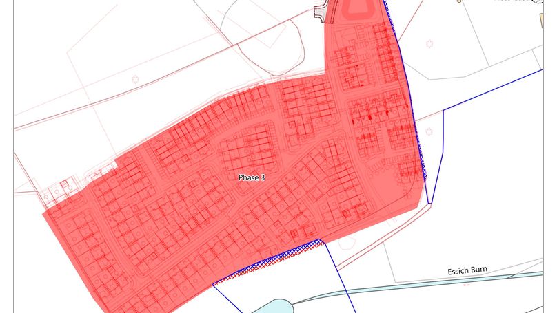
At Galbraith, we have been working with a major housing developer and the landowner for the last few years on a large development site on the western periphery of Inverness and close to Loch Ness. A key challenge was to bring together information from the developer’s plans with the landowner’s known legal ownership extents to ensure all development is contained within the land being sold.
Since the Land Reform (Scotland) Bill was established in 2014, Scotland’s Land Register has developed rapidly to allow greater visibility and access to ownership extents. This has been taking place alongside a wider digital transformation programme at Registers of Scotland. Nevertheless, straightforward access to digital mapping data is still a challenge and accurately comparing ownership extents against a developer’s plans requires mapping and GIS expertise.
We enjoy a well-established relationship with Registers of Scotland and have a good knowledge of their developing data transformation programme so are well placed to obtain and use accurate ownership extents. For this project we obtained the cadastral extents of the landowner so that they could be mapped accurately alongside the developer’s plans. This integration of different types of data enabled us to identify early that several areas fell outside the expected ownership.
Galbraith’s unique combination of good access to Registers of Scotland and well developed internal GIS technical expertise to manipulate multiple types of data resulted in us being able to provide the developer with this information. The developer is then in the position to amend their plans and avoid being in breach of title or planning.